Why We Built a New Tool
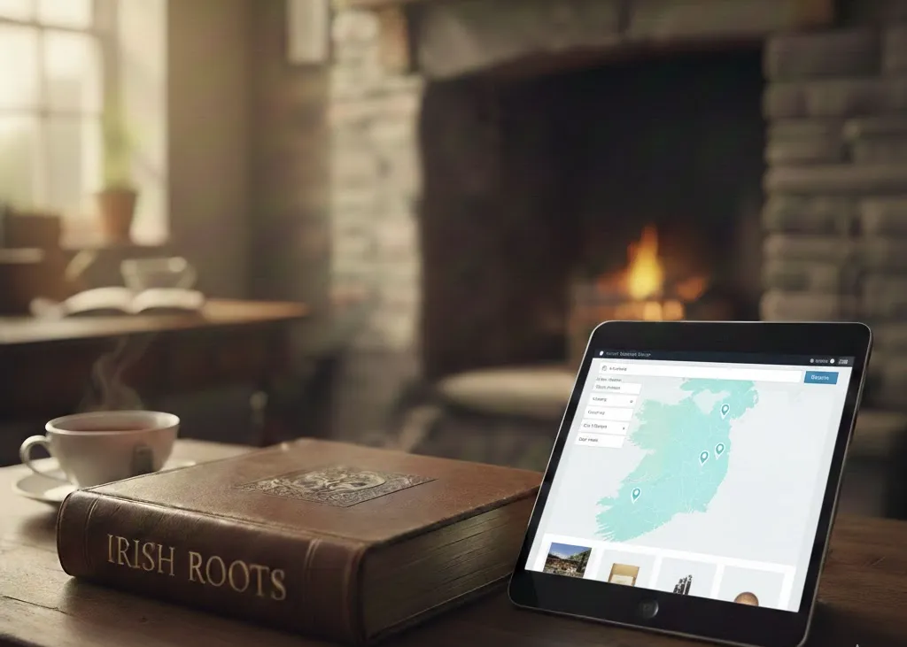
We are excited to announce the launch of our new Townlands search tool, now live at app.irishroots.ie. Over the past number of years, Townlands.ie has become an invaluable resource for anyone researching Irish geography, family history, or local heritage. Built on the extraordinary efforts of the OpenStreetMap community, it brought together detailed boundary data for Ireland’s 60,000+ townlands and made it accessible to researchers around the world. The dedication of volunteer mappers who digitised and refined townland boundaries created a foundation that has supported countless genealogical discoveries.
Our new tool at app.irishroots.ie was created in that spirit — not as a replacement in terms of mission, but as a continuation and enhancement of what made Townlands.ie so powerful. We are deeply grateful for the groundwork laid by the OpenStreetMap community and the developers who made townland mapping widely usable.
Over time, we found ourselves wanting additional functionality that would further support researchers, especially those tracing Irish ancestors.
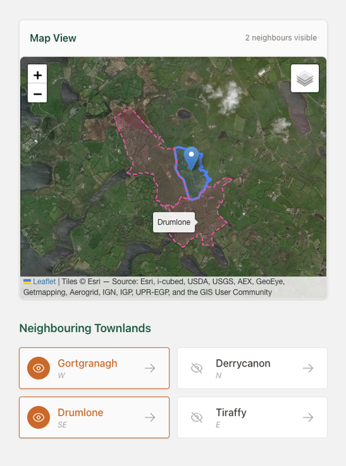
One of the first improvements we wanted was the ability to easily view adjacent townlands. In Irish research, neighbouring townlands are often just as important as the one you are initially investigating. Families frequently moved short distances, intermarried within neighbouring areas, or appeared in records under slightly different townland names. Being able to immediately see adjoining townlands adds vital context.
We also wanted to introduce a satellite view option. While traditional map layers are essential for boundary clarity, satellite imagery provides landscape context — helping users understand terrain, settlement patterns, and proximity to features like rivers, roads, or churches.
Another major focus was improving the mobile experience. Increasingly, researchers are working on tablets and phones — whether travelling through Ireland, visiting graveyards, or consulting records while on the move. We designed our interface to be just as fast and more usable on smaller screens.
Direct Census Integration
One of the most significant enhancements we have added is the direct loading of census data from the National Archives of Ireland for the 1901 and 1911 censuses. Rather than simply linking out, our system dynamically connects townlands with census returns, allowing users to move seamlessly between geography and household-level records.
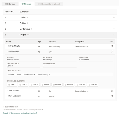
This integration required substantial work behind the scenes. While the 1901 and 1911 census collections are invaluable, they contain numerous transcription inconsistencies. Townland names were misspelled, abbreviated, or incorrectly entered during digitisation. In some cases, enumerators themselves recorded variant spellings.
Linking townlands to census records is therefore not as straightforward as matching names exactly. We have implemented matching logic that accounts for common spelling variations and transcription discrepancies. However, no automated system can catch every anomaly.
To address this, we have built a feedback mechanism directly into the app. If a user encounters a townland with no census information the app flags it. We then review these reports and correct underlying mismatches within 24 hours. This allows us to continuously improve data accuracy at speed.
Preparing for the 1926 Census
With the upcoming release of the 1926 census, preparation has been a key priority. We have structured our database and matching systems to accommodate the 1926 data as soon as it becomes fully accessible. Our goal is to integrate it quickly and cleanly, minimising the lag time between release and usability.
It is currently unclear whether Townlands.ie, which does not appear to be actively maintained at present (Last update: April 24, 2022, 8:30 a.m), will incorporate the 1926 census in a similarly integrated way. Our intention is to ensure that researchers using our platform will be able to access and connect this crucial new dataset as seamlessly as they can with 1901 and 1911.
Expanding Logainm and Civil Registration Districts
We have also expanded integration with Logainm.ie, Ireland’s authoritative placenames database. By adding more direct Logainm links for townlands, we enable users to explore official Irish-language forms, historical variants, and archival references with greater ease.
In addition, we are currently in the process of assigning the correct Civil Registration District (Poor Law Union) to every townland. For genealogists, understanding a townland’s registration district is essential when locating birth, marriage, and death records. By embedding this information directly into the mapping interface, we aim to reduce the need for cross-referencing multiple external resources.
A Living, Evolving Platform
This app is very much a work in progress. While we have already introduced significant enhancements — improved adjacency viewing, satellite mapping, mobile optimisation, census integration, Logainm expansion, and forthcoming registration district data, AI integration — there is much more to come.
One of the next major developments will be the introduction of name-based searching. This will allow users to search for surnames and see their geographic distribution across townlands, further strengthening the connection between place and family history.
Our vision is to build a living research environment that evolves alongside new data releases and user needs. By combining high-quality geographic mapping with deep archival integration, we hope to create a tool that supports both casual researchers and serious genealogists alike.
Above all, this project stands on the shoulders of the mapping volunteers and data stewards who made detailed townland geography accessible in the first place. We see our work not as replacing that foundation, but as extending it — ensuring that Irish townland research continues to grow, adapt, and remain accessible for years to come.
API Access
For developers and organisations who want to integrate townland data into their own applications, we also offer paid API access to our dataset. The API supports programmatic queries by townland name, county, and other parameters, returning structured data that you can use in your own tools, websites, or research workflows.
If you are building genealogy software, a local heritage website, or an educational resource, our API can save you the work of compiling and maintaining data yourself. There will also be AI MCP integration available shortly.
Try It Now
The townland search tool is free to use and available right now at app.irishroots.ie. We would love to hear your feedback as we continue to develop and improve the service. If you have suggestions, corrections, or feature requests, please get in touch.
This is just one of several tools we are building to make Irish genealogy research easier and more accessible. Stay tuned for more announcements in the coming weeks.